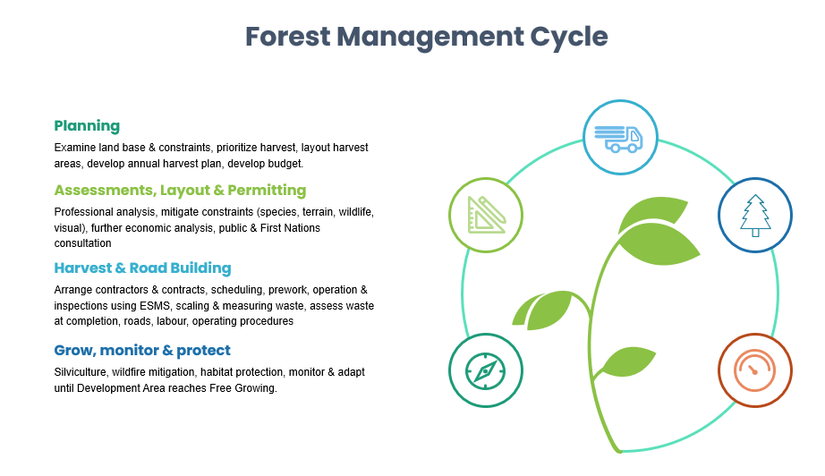
Forest Operations
NACFOR operations are designed to manage the community forest land base in a sustainable manner.
NACFOR manages 12,626 hectares of forest land base within the Regional District of Central Kootenay (RDCK), consisting of nine separate parcels, from Galena Bay to Arrow Park. Benefits flow to all communities in the catchment area, extending from Edgewood in the South to Galena Bay in the North, and East to Summit Lake Ski Hill. NACFOR operations revenue is used to hire local contractors, and management staff and distribute funds to our Donations program and Dividends and Legacy fund.
Don’t see something you are looking for? Contact the NACFOR management office.
Below is an interactive map of the NACFOR operating tenure around Nakusp.
2024/ 2025 Projects:
The public review and comment period on this Forest Operations Map (FOM) for the following plans is now closed, and the FOM is considered current for a three year period ending April 25, 2027.
Baerg/Slewiskin, Natural Resource District – Selkirk, Timber Supply Area – Arrow, Landscape Unit: N522 Caribou
The public review and comment period on this Forest Operations Map (FOM) for the following plans is now closed, and the FOM is considered current for a three year period, ending January 22, 2028.
FOM ID: 2113 – Woodlot License Plan #0406
Fosthall/ Wensley/ WL406 – Natural Resource District – Selkirk, Timber Supply Area – Arrow, Landscape Unit: N522 Caribou, N526 Fosthall
The public review and comment period on this Forest Operations Map (FOM) for the following plans is now closed. The FOM is considered current for a three year period, ending August 1, 2028.
Summit, Fosthall, Galena, Slewiskin – Natural Resource District – Selkirk – Timber Supply Area – Arrow – Landscape Unit: N522 Caribou, N523 Hills, N526 Vpond, N527 Fosthall, N529 Halfway